HDD Trenchless Technology Solutions HDD Plan projects is a new innovated HDD program.
Directional Drilling, River Crossing, Hydro Power water courses, Tunneling, Mining, Civil Engineering,
With a few inputs the software develops all the charting for Azimuth, Tangents, Turns and Bends and Dog Legs.
Download training videos

The purpose of this HDD Plan for Trenchless Technology Solutions program is to provide a user-friendly Borehole design interface for the unique requirements of the HDD (Trenchless Technology Solutions), industry to plan drilling boreholes starting and ending at any inclination and with multiple Tangent and Curve (Bend) sections. Applications for this program include civil engineering projects such as drilling under a river, road, airport runway, etc., to install utility shafts, drilling subway tunnels under cities, drilling hydro-electric water course tunnels, drilling mine shafts, etc. The program provides for five (5) contigious Tangent and/or Bend, Turn sections which suffices for most applications.. Purchase this program

The Minimum Curvature Method is used to calculate 3 dimentional Boreholes based upon X,Y,Z displacements for each section. The XYZ coordinates for this program equate to East-West (X), North-South (Y) and True Vertical Depth (Z). The user can input the length of each section either by measured depth (MD) length or true vertical depth (TVD) length. With Inclination and Azimuth inputs, the end point of each section is defined and the resulting Borehole is calculated with surveys generated at the User selected survey intervals up to 1000 surveys, on the Planned Survey sheet.
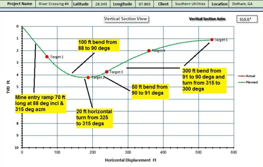
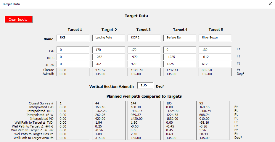
The HDD Plan for Horizontal Drilling program provides for up to five (5), Targets based upon true vertical depths (TVD’s), and (+E –W), (+N –S), distances from the RKB (rotary kelly bushing), surface location which is the datum (zero point), for all other measurements. Typically, Targets are determined by project constraints and then the Planned Borehole is designed to pass thru or near the Targets. The program also provides for input of Actual Surveys so actual drilling progress can quickly and easily be compared to the Planned Surveys and the Targets. Target closure distances and azimuths are compared to the closest point on both Planned and Actual Boreholes.

HDD Plan for Horizontal Drilling Charts of the Vertical Section view, Plan view and Dog Leg Severity (DLS) view are provided along with the Borehole parameters for each section such as section length, bend rate, turn rate, DLS, etc. The Planned and Actual surveys and Charts can be printed as needed.
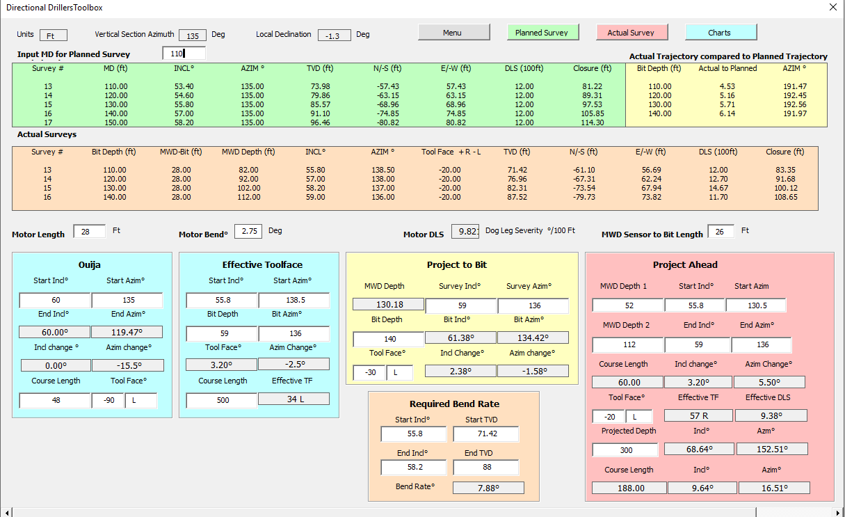
Tool Face Calculations, ![]()
Too Face Calculations include
Effective Tool Face
Project to bit
Project ahead
Checkout the Well Plan program